New features on the Parcel Viewer: Historical Maps!
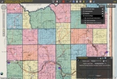
Screenshot of 1840 Layer selection in Parcel Map


The Cattaraugus County Office of Real Property and GIS Services is proud to present new historical map features on our Parcel Viewer! These appear as options within the map, that are able to be turned on and off. When turned on, you can compare the current layout of the county to what existed in the 19th century. There are 3 historical maps available:
1840 Cattaraugus County Map by David H. Burr
This map is viewable at the full extent of the county and shows town lines, Holland Land Company lots, county roads, villages and other landmarks that existed at the time.
1869 Beers Atlas
Not viewable at full extent of the county, this layer is a compilation of the separate maps of the towns within the county. These maps show roads, villages, rivers/creeks, and owner names of houses that were present at the time.
1955 Re-creation of Holland Land Company Map
Viewable at the full extent of the county, also shows town lines, Holland Land Company lots, roads and villages.
Disclaimer: Due to errors in the scanning and overlaying process, and even the original maps themselves, these maps are not exact and should be regarded as only a reference.
How to view these maps
The Parcel Viewer is available at Maps2.cattco.com/Parcel.
- Go to maps2.cattco.com/parcel.
- Read and agree to the terms in the popup disclaimer.
- Click the "More..." button.
- Click triangle next to "Historical Maps".
- Click the checkbox next to the layers you would like to see.
Please be patient as this can take several seconds for the map to be overlayed.